3D Scanning Fitness Complex

3D Scanning of a Large Fitness Complex Utilising TLS and SLAM Scanner
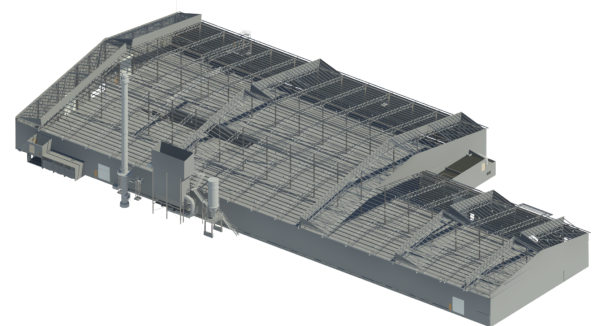
In our recent project we have applied Terresterial Laser Scanner and Slam handheld Scanner to complete 3D Scan of the entire ROAR fitness centre located in Bibra Lake (Western Australia). We have conducted 650 individual scans with TLS and over 3,000 sqm with Slam. These two datasets have been combined accurately to suit the needs of the project. The main objective of the project was re-desgin the internal spaces and renovatoin. In this case the role of 3D Scanning data is vital.
In the realm of architectural and engineering marvels, capturing precise measurements and detailed 3D models of large buildings has traditionally been a meticulous and time-consuming task. However, with advancements in technology, particularly in the field of 3D laser scanning, this process has been revolutionized, offering efficient solutions that combine accuracy with flexibility.
Terrestrial 3D Laser Scanners: Capturing Monuments of Precision
Terrestrial 3D laser scanners are formidable tools designed for capturing large-scale environments with utmost precision. These scanners operate on a stationary platform and utilize laser beams to map the surroundings in intricate detail. By rotating and capturing data from multiple angles, they create a comprehensive point cloud, which serves as the foundation for detailed 3D models. This method is ideal for capturing exterior facades, vast interiors, and complex architectural features of buildings, making it indispensable in fields such as urban planning, historical preservation, and construction.
Handheld SLAM Scanners: Flexibility Meets Detail
In contrast, handheld SLAM (Simultaneous Localization and Mapping) scanners offer unparalleled flexibility and mobility. These devices employ advanced algorithms to track their own position in real-time while mapping the environment. This allows them to capture intricate details in hard-to-reach areas, such as narrow corridors, intricate staircases, and areas with limited accessibility. Handheld SLAM scanners are particularly useful for capturing interior spaces where maneuverability and close-range precision are paramount.
Advantages and Applications
Both terrestrial and handheld SLAM scanners have distinct advantages:
- Terrestrial Scanners excel in capturing large-scale exteriors and interiors with high accuracy and detail.
- Handheld SLAM Scanners offer flexibility and accessibility, enabling detailed scans of confined or complex spaces.
These scanners find applications across various industries:
- Architecture and Construction: Facilitating accurate as-built documentation and planning.
- Engineering: Supporting structural analysis and retrofitting projects.
The Future of 3D Laser Scanning
As technology continues to evolve, the future of 3D laser scanning holds promise for even greater precision, speed, and accessibility. Enhanced integration with Building Information Modeling (BIM) systems and artificial intelligence will further streamline workflows and enhance the utility of scanned data in design and construction phases.
In conclusion, whether employing a terrestrial scanner for capturing monumental exteriors or a handheld SLAM scanner for intricate interiors, 3D laser scanning stands at the forefront of modern technology, revolutionizing how we document, analyze, and preserve our built environment. Its ability to combine precision with versatility makes it an indispensable tool in the arsenal of architects, engineers, and preservationists alike.
Exploring 3D Laser Scanning: Terrestrial vs. Handheld SLAM Scanners


3D Scanning and Modelling of Large Warehouse
Large Scale Steel Structure 3D Scan and 3D Model
3D laser scanning, also known as LiDAR (Light Detection and Ranging), is a powerful technology increasingly used in structural surveying. This method involves using laser beams to measure distances and create precise, three-dimensional models of structures and their environments.
By following this structured workflow and adhering to best practices, you can successfully convert point cloud data from a large warehouse scan into an accurate and detailed 3D solid model. This solid model can then be used for various purposes, such as renovation planning, structural analysis, or archival documentation.
Transforming the intricate point cloud data from a 3D laser scan of a large warehouse into a precise 3D solid model unlocks new dimensions of accuracy and insight, revolutionizing the way we approach structural design.


